Science
Building the city of tomorrow: Demand for geospatial talent grows as technology advances
Key Points
Building the city of tomorrow: Demand for geospatial talent grows as technology advances Geospatial intelligence, which helps planners tackle challenges ranging from EV charging infrastructure to urban heat, is becoming a key tool in planning future cities. Singapore’s future built environment will not just rise higher and extend deeper underground – it will also be planned using smarter data. As geospatial technology advances and as land becomes more scarce in Singapore, efforts are growing...
Building the city of tomorrow: Demand for geospatial talent grows as technology advances
Geospatial intelligence, which helps planners tackle challenges ranging from EV charging infrastructure to urban heat, is becoming a key tool in planning future cities.
SINGAPORE: Singapore’s future built environment will not just rise higher and extend deeper underground – it will also be planned using smarter data.
As geospatial technology advances and as land becomes more scarce in Singapore, efforts are growing to train more people who can turn complex datasets into better planning decisions.
Such technology is playing a bigger role in shaping everything from transport infrastructure and energy networks to neighbourhood design and underground spaces.
At the heart of this transformation is geospatial intelligence, a field that combines geography, computing, artificial intelligence and data analytics to uncover patterns that are not always visible on the ground.
PLANNING FOR AN ELECTRIC FUTURE
One area where geospatial intelligence is already making an impact is infrastructure planning for Singapore's electric vehicle (EV) transition.
As the nation moves towards its target of deploying 60,000 EV charging points by 2030, deciding where to place them has become a key challenge for planners.
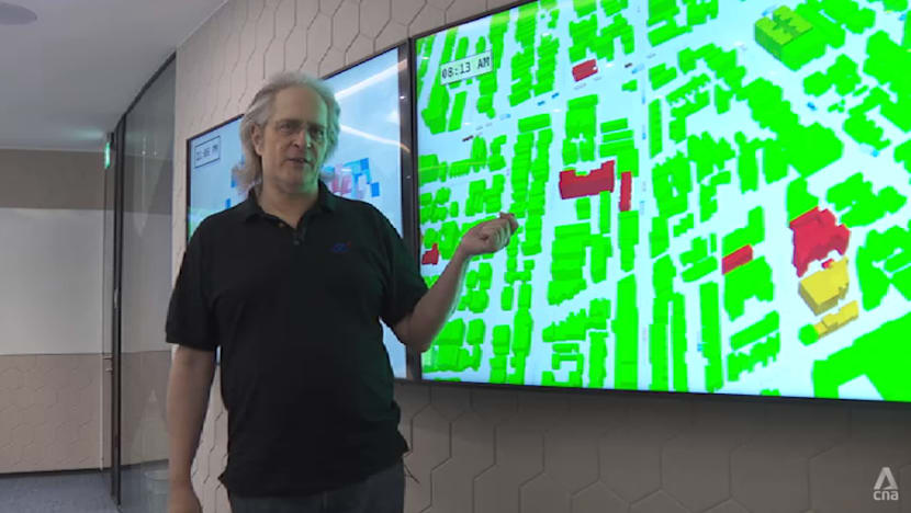
To support this effort, the Agency for Science, Technology and Research's (A*STAR) Institute of High Performance Computing has developed a simulation model that allows planners to forecast future charging demand across the island.
“We simulate the whole island. We see where all the vehicles go and where they plug in to get their energy,” said Dr Ilya Farber, a senior principal scientist at A*STAR’s social cognitive computing department.
Known as the Singapore Integrated Transport & Energy Model, it tracks the movements of different types of vehicles, including private cars, taxis and goods vehicles to estimate where and when charging demand is likely to occur.
This helps agencies determine the optimal locations for charging stations while also understanding how increased electricity demand will affect Singapore's power grid.
“We need to plan the energy grid to make sure it has the capacity to cover all that charging. We map all the chargers to the power grid, and agencies can use that to figure out which substations are going to need upgrading over time, and how fast,” said Dr Farber.
The simulation also accounts for differences in driver behaviour – some motorists may prefer fast chargers to quickly continue their journeys, while others may opt for slower chargers near their homes and charge overnight.
Rather than relying on current petrol station usage patterns, the model simulates how drivers are likely to adapt to different charging options and locations.
“This allows agencies … to model scenarios that are of interest, test their plans and see how well they'll work (so as) to predict in a more realistic way what charging demand is going to look like,” Dr Farber said.
He added that future versions of the simulation could help urban planners evaluate different township and neighbourhood designs before they are built, allowing them to anticipate future energy demand and determine what infrastructure upgrades may be needed.
MORE LIVEABLE NEIGHBOURHOODS
The use of geospatial technologies extends far beyond transport and energy planning.
The National University of Singapore (NUS) will be launching a new geospatial intelligence major in August under its Bachelor of Science Cross-Disciplinary Programme to prepare students for careers at the intersection of geography, data science and computing.
“Geospatial intelligence is mainly for extracting actionable insights so (we) could address real-world problems,” said Associate Professor Feng Chen-Chieh, programme director for geospatial intelligence at NUS' Department of Geography.
Applications range from improving access to amenities and green spaces to planning underground infrastructure and designing more liveable neighbourhoods.
For example, satellite imagery and geospatial AI can be used to identify urban heat hotspots. Policymakers can then use those insights to develop measures that reduce the urban heat island effect in densely built-up areas.
“The common applications, especially for Singapore, are about (creating) a sustainable and liveable city,” Assoc Prof Feng said.
“It could be an application related to accessibility – within 15 minutes (whether people can easily) access clinics or parks … basically satisfy everyday needs.”
Geospatial intelligence is also increasingly being used to create digital representations of both above-ground and underground environments, he said.
These digital models can be combined with human behavioural data to help planners understand how people use spaces and how future developments can be designed more efficiently.
NEXT GENERATION OF TALENT
The adoption of geospatial technologies is also driving demand for workers with expertise in both spatial analysis and computing.
According to Assoc Prof Feng, student interest in geospatial-related courses has risen by 25 per cent over the past two years across different faculties such as law and business.
NUS expects an inaugural cohort of about 30 students for the new programme, with plans to double enrolment over the next four years.
Graduates could find opportunities in fields such as urban planning, environmental science, public health and business analytics, where location-based intelligence is becoming increasingly important, said Assoc Prof Feng.
“It's not going to be just spatial or just computing; they need the combination of the two, so that you can generate the insights correctly,” he said.
As Singapore continues to build higher and deeper, geospatial intelligence is emerging as a critical tool for understanding how people, infrastructure and resources interact.
Observers said the planners and data specialists trained today could play a key role in shaping a future city that is not only more efficient, but also more liveable.