
Politics
CNA Explains: How Singapore could reclaim more land in the future
Key Points
CNA Explains: How Singapore could reclaim more land in the future With major reclamation works on the horizon, CNA looks at how reclamation methods have evolved. SINGAPORE: Singapore has the world’s most reclaimed land by proportion – taking up over a quarter of its 744 sq km land area. That could soon increase, with major reclamation works on the horizon.
CNA Explains: How Singapore could reclaim more land in the future
With major reclamation works on the horizon, CNA looks at how reclamation methods have evolved.
SINGAPORE: Singapore has the world’s most reclaimed land by proportion – taking up over a quarter of its 744 sq km land area.
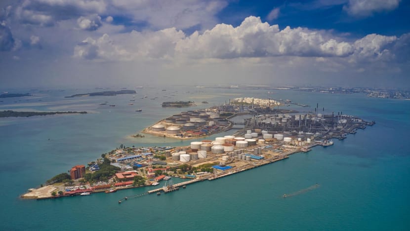
That could soon increase, with major reclamation works on the horizon. Prime Minister Lawrence Wong announced at the 2026 National Day Rally that Singapore is considering merging several islands south of Jurong Island into a larger western island over the coming decades.
Preparatory works for "Long Island", Singapore's large-scale coastal protection strategy, will start at the end of 2026 to lay the groundwork for the decades-long, 800ha project.
But conventional land reclamation methods, such as infilling, have been hampered by rising costs and a limited supply of fill material, experts said. There are also concerns about the environmental impact.
Singapore has already been exploring alternative methods. In September last year, it reclaimed 800ha of land at Pulau Tekong through empoldering, a method that cut sand use by almost half but is more costly to maintain.
What could the future of land reclamation look like? CNA speaks to geotechnical experts to find out.
How much of Singapore's land is reclaimed?
Land reclamation began as far back as 1822 at the south bank of the Singapore River, where Boat Quay stands today. Under British rule, Collyer Quay, Telok Ayer and later Kallang Basin and Beach Road were also reclaimed, according to the National Library Board's BiblioAsia.
In total, about 300ha or 3 sq km of land was added then, roughly the size of 420 football fields. Post-independence, Singapore added a further 160 to 165 sq km, growing from about 581.5 sq km in 1965 to 744 sq km today.
For example, the East Coast Reclamation Scheme, launched in 1966 and carried out over seven phases until 1986, reclaimed about 15 sq km of land that today includes East Coast Park, the East Coast Parkway (ECP) and housing estates such as Marine Parade.
Reclaimed land now makes up about 28 per cent of Singapore's total land area, said Associate Professor Darren Chian of the National University of Singapore's (NUS) Department of Civil and Environmental Engineering, whose expertise includes land reclamation.
In the early post-independence years, the government focused on rapid urbanisation and essential infrastructure, driving projects such as the East Coast Reclamation to build public housing and Changi Airport, said Assoc Prof Chian.
As the economy matured through the 1990s and 2000s, priorities shifted towards high-value global services, with the development of Jurong Island and the expansion of the financial hub at Marina Bay.
Today, reclamation projects such as the upcoming Long Island also address long-term climate resilience, raising baseline land elevations to protect coastal areas from rising sea levels, he added.
How has Singapore traditionally reclaimed land?
In the early years, land reclamation was carried out with hill-cut materials, or soil excavated from hills, said Professor Chu Jian, President's Chair in Civil Engineering at Nanyang Technological University (NTU).
Tampines, for example, had hills excavated so their soil could be used for reclamation, he said.
"For later years of land reclamation, we don't have hills to cut anymore, so we start to import sand," he said, pointing to Jurong Island, Chinese Garden and Changi East as areas reclaimed using imported sand.
Because of the limited supply of fill material, Singapore has also turned to marine clay from sea wall construction and excavated material from MRT construction and buildings, he added.
To reclaim land, a dike or sea wall is built along the boundary of the proposed land area before it is filled with material.
“Ideally, sand should be used because it's easy to handle, and also sand is less compressible. If you use clay, it’s very difficult to treat … the cost of improvements will also be higher,” said Prof Chu.
“But of course, the cost of sand is getting higher and higher, and also, it may not be easily available.”
The challenge of getting enough fill material for land reclamation is compounded by the need for more as Singapore goes deeper into the sea for reclamation, experts said.
One hectare of sea about 10m deep needs about 100,000 cubic metres of fill material, whether sand, approved soil or approved dredged material, said Mr David Ng of the Institution of Engineers, Singapore (IES).
Most reclamation today is done for seabed depths of up to 20m, said Mr Ng, who is also co-founder and executive director of One Smart Engineering.
Assuming an average seabed depth of 20m, the 800ha Long Island could need at least 160 million cubic metres of infill material by a rough estimate, or roughly the volume of 64,000 Olympic-sized swimming pools, said Mr Ng.
How are land reclamation methods evolving?
Singapore has shifted to the polder method for the recent Pulau Tekong project, using surrounding dikes and continuous pumping systems to create usable land below sea level, said Assoc Prof Chian.
“The polder method cuts sand volume demands significantly, but it carries higher engineering complexity and ongoing long-term operational costs due to the need for continuous pumping systems and dike maintenance,” he said.
Alternative recycled materials such as excavated soil or treated marine clay eliminate reliance on imported sand and divert local construction waste from landfills, though they require specialised chemical treatment and ground-stabilisation techniques, he added.
Such materials are "excellent sustainability initiatives", said Associate Professor Edward Park, a principal investigator at the Earth Observatory of Singapore whose research focuses on sand mining. But the volume generated is often only a small fraction of the hundreds of millions of cubic metres required for major reclamation projects.
“They oftentimes simply cannot supply the massive scale of demand,” he said.
“Other theoretical alternatives include manufactured sand (crushed rock). However, producing manufactured sand at reclamation scales is highly energy-intensive and prohibitively expensive. Because of these logistical and economic realities, sand will continue to see the biggest demand for bulk land creation in the foreseeable future.”
For Long Island, engineers are likely to adopt hybrid polder systems, using protective perimeter dikes and drainage networks to create land below sea level, significantly reducing the volume of fill required, he said.
The western island merger, if it goes ahead, will likely follow the blueprint used for Jurong Island, constructing heavy containment bunds to link several southern offshore islands and infilling the shallow waters between them to create a unified landmass, he added.
“While natural sand may still be necessary for critical structural elements like dike foundations and seawall revetments, combining polder designs with recycled local materials will allow Singapore to execute these megaprojects with a much smaller environmental footprint,” he said.
How can impact on the environment be mitigated?
Environmental experts have said that large-scale reclamation projects would disrupt ecosystems and lead to habitat and biodiversity loss. The sea around the islands proposed for development in the west, for instance, is home to rich coral reefs and marine life that could be permanently erased or altered.
The Ministry of National Development has said it recognises the biodiversity value of the western Islands and their surroundings, and is studying the plans as "there is a need to plan ahead and create options for the future".
As part of the planning process, it will conduct technical studies, including environmental assessments, to inform any development plans.
“Definitely, we cannot completely avoid environmental impact. However, there are methods for us to reduce the environmental impact,” said NTU’s Prof Chu, pointing to environmental studies as a way to guide reclamation works.
A marine ecosystem can also be restored post-reclamation, he said, citing East Coast's new environment as an example.
IES' Mr Ng said research is under way to explore the possibilities. "For these upcoming land reclamation projects, it is really necessary to study and explore the use of more sustainable design and construction methods and materials to minimise impacts on the surrounding marine and coastal environment," he said.
One potential approach combines floating structures with reinforced concrete caissons - watertight retaining structures - with usable undersea space for various purposes. Floating structures could also be used with the caissons to create usable space above sea level, while the new coastline of the reclaimed land is made conducive for marine life, he said.
CNA (LOCATION)
Singapore (LOCATION)
Lawrence Wong (PERSON)
National Day Rally (EVENT)
Jurong Island (LOCATION)
Pulau Tekong (LOCATION)
the Singapore River (LOCATION)
Boat Quay (LOCATION)
British (ORG)
Collyer Quay (PERSON)
Telok Ayer (ORG)
Beach Road (LOCATION)
the National Library Board's (ORG)
BiblioAsia (LOCATION)
the East Coast Reclamation Scheme (LOCATION)