
Politics
UN to vote on adopting new world map that shows true size of all countries
Key Points
UN to vote on adopting new world map that shows true size of all countries Africa-led campaign asks governments, schools and tech firms to move away from the centuries-old Mercator projection - Bookmark - CommentsGo to comments The UN general assembly is due to vote on a resolution calling for the world to move away from the traditional Mercator map, which shrinks the size of Africa and exaggerates northern landmasses, in favour of designs that more accurately reflect the true size of...
UN to vote on adopting new world map that shows true size of all countries
Africa-led campaign asks governments, schools and tech firms to move away from the centuries-old Mercator projection
- Bookmark
- CommentsGo to comments
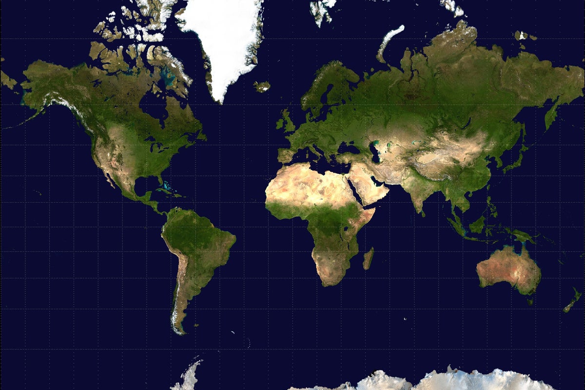
The UN general assembly is due to vote on a resolution calling for the world to move away from the traditional Mercator map, which shrinks the size of Africa and exaggerates northern landmasses, in favour of designs that more accurately reflect the true size of countries.
The draft resolution asks governments, schools, international organisations, and technology companies to adopt the Equal Earth projection and other equal-area maps wherever the true scale of continents matters, with the aim of establishing more proportionally accurate maps as a new global norm. It does not seek to ban the Mercator projection outright.
The vote is set for Friday.
The Mercator projection, which is currently used worldwide, increases distortion the further a region sits from the equator. Since Africa straddles the equator, it seems comparatively smaller than its actual size, while Europe, North America, Greenland, and Russia all appear substantially larger than they are.
As a result, Africa, along with Latin America, India and other equatorial regions, appear much smaller relative to northern countries than their true area. The map, for example, depicts Africa as similar in size to Greenland, despite the continent being 14 times larger than the Danish territory.
The UN resolution was brought by Togo with the African Union’s backing, Togo's foreign minister Robert Dussey said. He did not specify the total number of nations that were supporting the vote.
In a briefing to the African Group at the UN this week, he said the importance of the issue went beyond geography.
"A map is never neutral," Mr Dussey reasoned. “It shapes perceptions, influences how the place of peoples and continents in the world is understood, and may, sometimes from the earliest years of schooling, perpetuate representations that do not correspond to geographic reality."
"Africa is not asking for preferential treatment," he said. "Africa is asking that its reality, aspirations and contribution to the international system be duly taken into account."
He urged African delegations to broaden support for the resolution before Friday's vote, which he described as a test of the continent's ability to act with one voice at the UN.
Togo hosted a reception for all UN member states on the eve of the vote as part of that push.
Mr Dussey said he was aiming for as broad a consensus as possible when asked if he expected opposition to the resolution.
"I'm an academic before a politician," he said. "As an academic, I say we have to have as large a consensus as possible, because we are here at the UN, we never know.”
A petition on the fundraising platform Change for the campaign, called #CorrectTheMap, had gathered around 11,000 signatures ahead of the vote. The African Union endorsed the campaign in August 2025 and asked Togo to lead the push for its adoption at the UN.
“As Africa becomes increasingly central to solving global challenges,” the petition says, “it is critical to represent its true scale.”
Historians and geographers have long argued that the Mercator map reflects Western assumptions about the world, and some campaigners have used the term "cartographic colonialism" to denounce what they have described as its negative effects.
German historian Arno Peters was one of the most prominent critics of the projection, launching an alternative map based on the Gall-Peters projection in 1973. Togo's campaign is instead promoting the 2018 Equal Earth map, developed by an international team of cartographers, which supporters say offers a more accurate representation of the size of every continent.
Mr Dussey connected the map campaign to another African Union-backed resolution passed at the UN in March which described the transatlantic slave trade as the "gravest crime against humanity" and was approved by 123 states, with three against and 52 abstentions.
If the resolution passes, Togo's government will hold an event in the capital, Lomé, with Unesco, the African Union, and technology companies including Google Maps in the first quarter of next year to work out how the change may be implemented.
Join our commenting forum
Join thought-provoking conversations, follow other Independent readers and see their replies
Comments