
Science
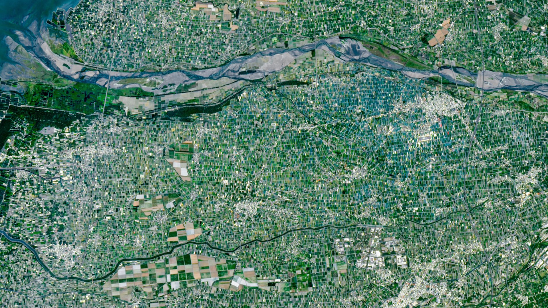
Multicolored 'mosaic' of mini farms surrounds Taiwan's largest river — Earth from space
Key Points
Multicolored 'mosaic' of mini farms surrounds Taiwan's largest river — Earth from space A recent satellite photo shows a patchwork of tens of thousands of size-restricted farms tightly crammed into Taiwan's Yunlin County, which grows a majority of the island's food. QUICK FACTS Where is it? Yunlin County, Chianan Plain, Taiwan [23.78563273, 120.44373747]
Multicolored 'mosaic' of mini farms surrounds Taiwan's largest river — Earth from space
A recent satellite photo shows a patchwork of tens of thousands of size-restricted farms tightly crammed into Taiwan's Yunlin County, which grows a majority of the island's food.
QUICK FACTS
Where is it? Yunlin County, Chianan Plain, Taiwan [23.78563273, 120.44373747]
What's in the photo? A multicolored 'mosaic' of small, tightly compacted farms
Which satellite took the photo? Landsat 9
When was it taken? April 24, 2026
This recent satellite snap shows off a multicolored "mosaic" of tightly packed mini farms covering part of Taiwan in the western Pacific Ocean. The sea of fields and shade nets demonstrates the scale of the agricultural challenges facing the densely populated island.
Taiwan is 14,000 square miles (36,000 square kilometers) — about the same size as Maryland — but has a population around four times as large, with approximately 23 million people living there, according to NASA's Earth Observatory. This places a heavy burden on the island's agricultural industry to provide enough food for everyone on the island, especially as large parts of the landmass are covered by mountains and rainforest.
Researchers estimate that there is only around 3,200 square feet (300 square meters) of Taiwanese farmland per citizen, which is around two-thirds the size of a basketball court, according to the Earth Observatory. This is around 10 times less than the equivalent for U.S. citizens.
The majority of the island's food is produced within Yunlin County, which is situated around halfway along the Chianan Plain, a lengthy strip of flat terrain that hugs Taiwan's west coast. Just under half of the county is visible in the satellite image, which spans roughly 15 miles (24 kilometers) across.
The flat ground in Yunlin County, as well as access to water from the island's largest river, the Zhuoshui (visible across the top of the image), makes it an ideal place to grow a variety of different crops, including "rice, sweet potatoes, peanuts, corn, sugarcane, garlic, scallions, coffee, fruit, and leafy greens," Earth Observatory representatives wrote.
The average size of a farm in Yunlin County is under 100,000 square feet (10,000 square m), which is around 90 times smaller than the average U.S. farm. As a result, the region looks like a giant patchwork of tens of thousands of irregular cuboids when viewed from above.
The sizes of Taiwanese farms are restricted by longstanding legislation that limits the amount of land any individual can own, according to the Earth Observatory. Most of the farms are passed down from generation to generation.
Get the world’s most fascinating discoveries delivered straight to your inbox.
While Yunlin County's agricultural mosaic is fairly consistent across this image, two main areas stand out from the rest (see below).
The first outlying region is a swarm of blue and turquoise rectangles surrounding the town of Xiluo in the upper right of the image (just below the river). These farms are covered with plastic shade nets, which shelter them from harsh sunlight in the summer and monsoon-like rains in the wet season
The second and perhaps most noticeable anomaly is a cluster of much larger, lightly colored farms near the town of Baozhong (bottom left of the photo). These are sugarcane fields, left over from when Japan controlled Taiwan between 1895 and 1945.
A large portion of the Chianan Plain was used to grow sugarcane by the Japanese, who also constructed railway lines to move the crop across the island. However, most of these fields have since been repurposed, and all but one of the railway lines have fallen out of use.
In addition to growing crops, these small farms are used to rear livestock, including chickens, cattle and "millions of pigs," according to the Earth Observatory.
See more Earth from space
Lost 'heart' of the Colorado River
A 2016 astronaut photo mosaic highlights a "sunglint" phenomenon that transformed Lake Powell into a winding metallic "river." The artificial reservoir, which is the second largest in the country, is home to many visible and long-lost geological wonders.
Giant 'sponge' dome looms over Brazil
A 2025 satellite photo shows the Caldas Novas dome, a 12-mile-long monolith that towers above the Brazilian state of Goiás. The structure acts as a giant sponge, soaking up water that helps fuel nearby hot springs.
Salt slab lurks on Sahara's tallest peak
A 2024 astronaut photo captured an unusual salt patch shining like snow on top of northern Chad's imposing Emi Koussi volcano, which is covered with ancient lava, hidden vents and shadowy waterways.
Harry is a U.K.-based senior staff writer at Live Science. He studied marine biology at the University of Exeter before training to become a journalist. He covers a wide range of topics including space exploration, planetary science, space weather, climate change, animal behavior and paleontology. His recent work on the solar maximum won "best space submission" at the 2024 Aerospace Media Awards and was shortlisted in the "top scoop" category at the NCTJ Awards for Excellence in 2023. He also writes Live Science's weekly Earth from space series.
You must confirm your public display name before commenting
Please logout and then login again, you will then be prompted to enter your display name.
Taiwan (LOCATION)
Earth (LOCATION)
Multicolored ' (ORG)
Yunlin County (LOCATION)
Chianan Plain (LOCATION)
Pacific Ocean (LOCATION)
Maryland (LOCATION)
NASA (ORG)
Earth Observatory (LOCATION)
Taiwanese (ORG)
the Earth Observatory (LOCATION)
U.S. (LOCATION)
the Chianan Plain (LOCATION)
Zhuoshui (PERSON)
Yunlin County's (LOCATION)