
Weather
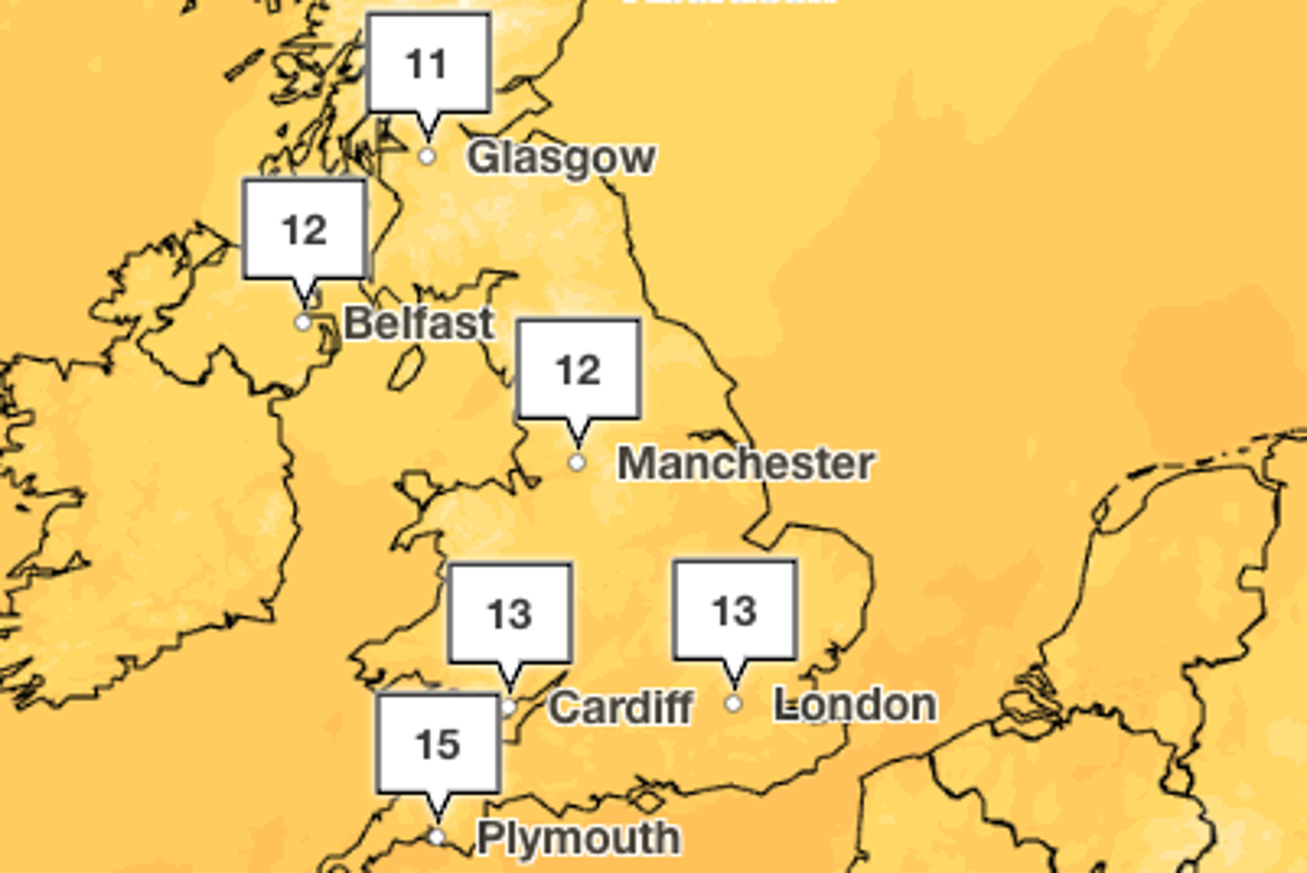
Weekend weather forecast: Where heavy rain will hit UK with temperatures set to plummet
Key Points
Weekend weather forecast: Where heavy rain will hit UK with temperatures set to plummet Temperatures across the UK are expected to drop after a spell of unseasonably warm weather - Bookmark - CommentsGo to comments Become an Independent member to bookmark this article Already a member? Log in Parts of the UK have enjoyed an unseasonably warm spell for mid-October, with temperatures climbing as high as 23C in central and southern parts of England – well above the monthly average. But the warm...
Weekend weather forecast: Where heavy rain will hit UK with temperatures set to plummet
Temperatures across the UK are expected to drop after a spell of unseasonably warm weather
- Bookmark
- CommentsGo to comments
Become an Independent member to bookmark this article
Already a member? Log in
Parts of the UK have enjoyed an unseasonably warm spell for mid-October, with temperatures climbing as high as 23C in central and southern parts of England – well above the monthly average.
But the warm weather is set to end as a band of rain moves slowly across the south and east of the country, sweeping away the mild air and opening the door to much colder conditions from the north.
According to the Met Office, temperatures will fall by several degrees heading into the weekend, with heavy rain forecast in the east and south east of England. Elsewhere, clearer skies are expected to bring frost and a crisp autumnal chill.
Temperatures are set to plummet to highs of around 16C on Friday, marking a huge change from Thursday’s highs of over 20C.
Rain is forecast across the south east, but will clear by the afternoon, bringing in a period of high pressure across the UK for the weekend.
Saturday will be largely dry and settled for many, with sunny spells, generally light or moderate winds and temperatures around or slightly below average for the time of year, according to the Met Office.
However, those in coastal areas in the east and south east of England can expect some “potentially heavy showers”. Daytime maximums will drop into the low-to-mid teens for most areas, while outer parts of Scotland, Northern Ireland, and northern England could see nighttime temperatures approach freezing.
In Scotland and parts of England, temperatures are forecast to hover at around 10C. The rest of the UK will see slightly warmer weather, with an expected maximum of 14C.
On Sunday, conditions will remain largely dry and settled for many, but however there is a chance of rain across parts of eastern and southeastern England during the day. Temperatures will reach highs of 13C, with much of the country closer to 10C.
Met Office chief forecaster, Chris Bulmer said: “For many, this weekend brings a window of dry and bright autumn weather, with some sunny spells and light winds as high pressure stays dominant. Overnight may feel particularly chilly, and those in eastern and southeastern areas should watch out for some heavy showers.
“There are signs that high pressure will loosen its grip through next week, allowing for lower pressure and Atlantic weather systems to have more influence by the end of the week, increasing the chance of spells of wet and windy weather for all areas.
“There is still some uncertainty in the likely change in weather patterns through next week with details expected to become clearer over the coming days.”
The Met Office has forecasted that high pressure will build nearer the UK towards the end of the month, delivering settled, but cooler conditions alongside mist, fog patches, and increasingly frequent morning frosts.
These lower temperatures come after the UK recorded its joint-fourth warmest September ever, according to provisional figures from the Met Office.
The maximum temperature was as high as 28.1C on 29 September, the forecaster said, level with September figures from 1949 and 2016.
But while the colder weather is expected to bring welcome respite from a summer of back-to-back heatwaves, large swathes of the country remain in drought.
Drier conditions have continued into this autumn, with research by the Environment Agency showing England needs 20 per cent more rainfall than average until the end of April for all of the areas to emerge from drought status.
Met Office five-day forecast
Friday
Rain will clear southeast England by early afternoon. Otherwise, sunny spells are expected, although showers will feed in across the UK, most frequent in the northwest. Feeling cool in a north to northwesterly wind.
Saturday
Mostly dry with sunny spells on Saturday. Showers are likely near some eastern coasts. Temperatures around average by day, but with a risk of an overnight frost.
Outlook for Sunday to Tuesday:
A chilly start on Sunday, with patchy frost and fog. Dry spells with sunshine will follow, although showers may affect eastern areas later. Turning cloudier and breezier from Monday.
Join our commenting forum
Join thought-provoking conversations, follow other Independent readers and see their replies
Comments
[Image text:] 12
11
Glasgow
Belfast
12
Manchester
13
13
15
Cardiff
Plymouth
London