
Weather
UK to see warm spell with temperatures as high as 26C before wind and rain hit
Key Points
UK to see warm spell with temperatures as high as 26C before wind and rain hit The period of warm weather could be followed by a spell of heavy rain across parts of Scotland and north-eastern England on Wednesday and Thursday - Bookmark - CommentsGo to comments The UK is expected to experience a warm spell in the coming days, with temperatures potentially reaching as high as 26C in some areas. A period of high pressure will dominate in the UK, bringing sunshine and warm temperatures across...
UK to see warm spell with temperatures as high as 26C before wind and rain hit
The period of warm weather could be followed by a spell of heavy rain across parts of Scotland and north-eastern England on Wednesday and Thursday
- Bookmark
- CommentsGo to comments
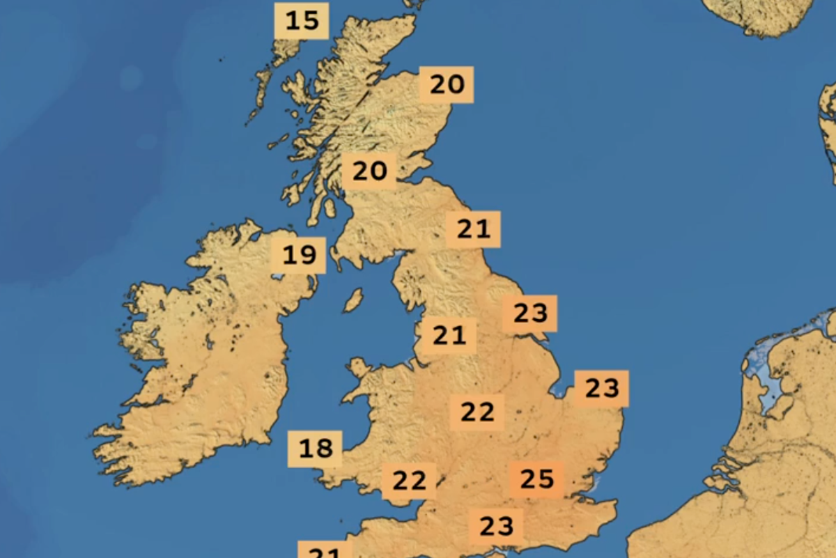
The UK is expected to experience a warm spell in the coming days, with temperatures potentially reaching as high as 26C in some areas.
A period of high pressure will dominate in the UK, bringing sunshine and warm temperatures across the country, especially in the South East.
But parts of the North West will also face patchy rain on Tuesday, as a cold front moves across the country from north-western areas, the Met Office said in its latest forecast.
Monday is “dry, warm and sunny across southern parts of the UK”, the forecaster said, with increasing cloud and the possibility of patchy rain further north and west.
Areas in Scotland and Northern Ireland will have a mix of cloud, brighter spells and rain as a cold front gradually moves southeastwards on Tuesday.
“The warmest conditions are expected to remain in the southeast, where temperatures could reach 25C, with a potential maximum of 26C,” the forecaster said.
From Wednesday, the weather will become more difficult to predict as a series of several weather fronts move across the UK.
“There remains some uncertainty over the exact track of a frontal system on Wednesday which could bring a spell of heavy rain, particularly across eastern and southeastern Scotland, and potentially parts of northern and northeastern England,” added deputy chief forecaster Tony Wisson.
"We're closely monitoring this development and would encourage people to keep up to date with the latest forecasts over the coming days. It’s likely that many southern areas will remain largely dry.
"It’s set to be a notably chilly night on Wednesday into Thursday, with a chance of localised air frost in some rural locations, as cooler air moves in from the North West.
"Thursday should bring long sunny spells for much of England and Wales, though we're also monitoring the potential for strong winds to affect the far North West of the UK. Temperatures in London may reach around 22C, but another cool night is likely to follow in the South.
"With watchpoints ahead this week, it's a good idea to keep an eye on the forecast as the week goes on.”
The current spell of warm weather is the result of a deep area of low pressure which is forming to the west of the UK. Despite not moving over the country, it is “dragging warmer air up from the continent and the subtropical Atlantic”, the Met Office said.
It comes after more autumnal weather has hit the UK since the start of September, following the hottest summer on record, in which parts of the country experienced as many as five heatwaves and still remain in drought.
Met Office five-day forecast
Monday
Dry, warm and sunny in the South with light winds. Cloud thickening in the North and West, with patchy light rain possible at times. Feeling warm where the sunshine develops.
Monday night
Staying cloudy in the North and West with patchy drizzle possible where the cloud thickens. Clear spells elsewhere with mist and fog patches possible.
Tuesday
Cloudy for many with a few bright spells at times. Rain moving into north-west Scotland and Northern Ireland through the day. Rather sunny and warm in the South East.
Wednesday to Friday
A spell of heavy rain moves through on Wednesday, followed by a drier, brighter and fresher day on Thursday. Clouding over again on Friday with light rain moving south.
Join our commenting forum
Join thought-provoking conversations, follow other Independent readers and see their replies
Comments
[Image text:] 15
20
20
19
18
21
21
23
22
23
22
25
23
UK (LOCATION)
Scotland (LOCATION)
England (LOCATION)
the South East (LOCATION)
the North West (LOCATION)
the Met Office (ORG)
Northern Ireland (LOCATION)
Tony Wisson (PERSON)
Wales (LOCATION)
North West (LOCATION)
London (LOCATION)
South (LOCATION)
watchpoints (ORG)
Atlantic (LOCATION)
North (LOCATION)