
Breaking News
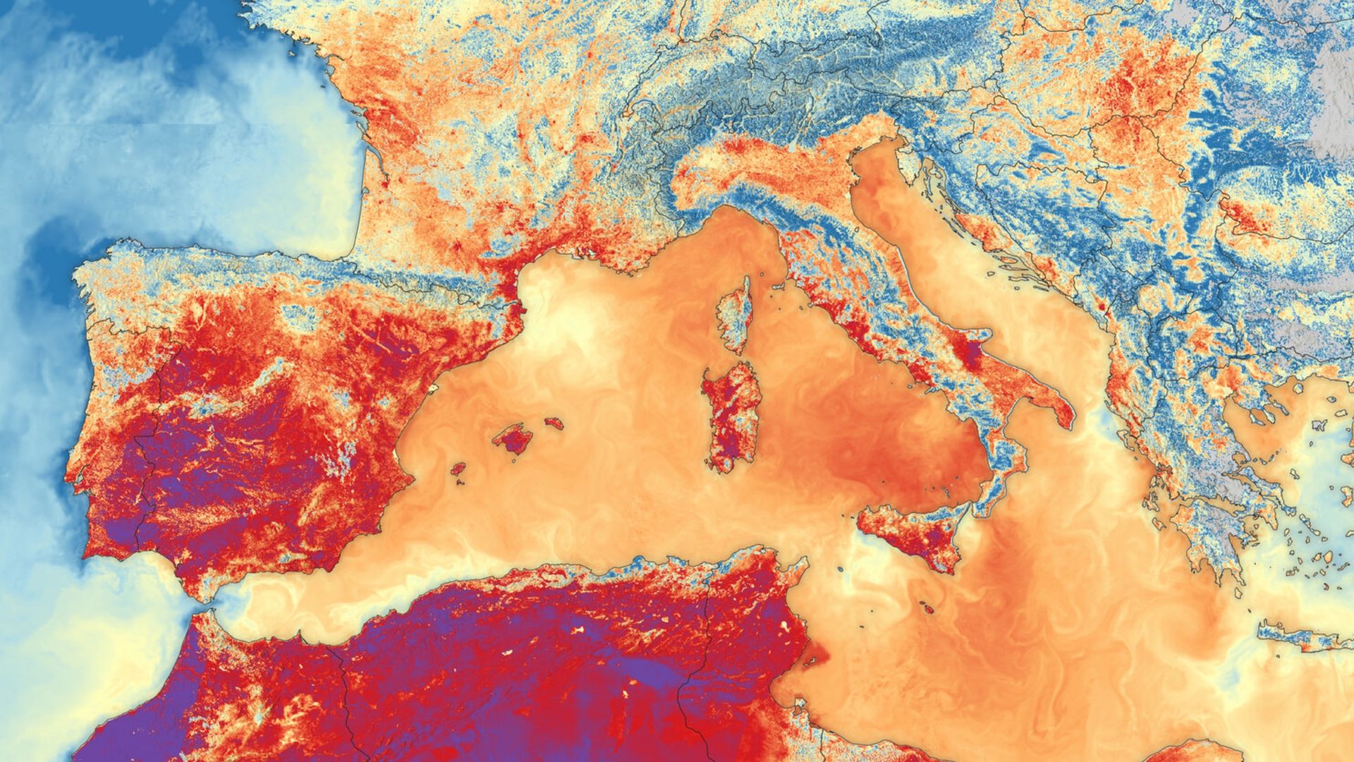
'It makes me feel that we can do a lot about it': ESA official shares striking satellite snap of Europe's record-breaking summer heat waves
Key Points
'It makes me feel that we can do a lot about it': ESA official shares striking satellite snap of Europe's record-breaking summer heat waves — Earth from space The head of ESA's Earth observation program tells Live Science why a striking image of a recent heat wave scorching Southern Europe gives her hope that we can properly monitor — and eventually prevent — similar extreme weather events in the future. QUICK FACTS Where is it? Southern Europe and North Africa
'It makes me feel that we can do a lot about it': ESA official shares striking satellite snap of Europe's record-breaking summer heat waves — Earth from space
The head of ESA's Earth observation program tells Live Science why a striking image of a recent heat wave scorching Southern Europe gives her hope that we can properly monitor — and eventually prevent — similar extreme weather events in the future.
QUICK FACTS
Where is it? Southern Europe and North Africa
What's in the photo? Land and sea surface temperatures during one of Europe's record-breaking summer heat waves
Which satellite took the photo? Sentinel-3B
When was it taken? June 23, 2026
This striking satellite snap shows the scorching land and sea surface temperatures that hit Southern Europe during one of the continent's record-breaking heat waves this summer.
The image was created using data from the Sea and Land Surface Temperature Radiometer (SLSTR) on board the European Space Agency's (ESA) Sentinel-3B satellite. It was selected for this week's edition of Earth from space by Simonetta Cheli, director of Earth observation programs at ESA and head of the European Space Research Institute (ESRIN) in Frascati, Italy.
Live Science recently visited Frascati to see ESRIN's newly operational Space HPC supercomputer and sat down with Cheli for an in-depth discussion about Earth observation. When asked about her favorite satellite image, Cheli highlighted this photo as one that caught her eye this year.
In the thermal image, dark reds highlight terrestrial temperatures in excess of 95 degrees Fahrenheit (35 degrees Celsius) across most of Spain and parts of France and Italy, while dark purple spots show highs above 104 F (40 C) across patches of Spain and North Africa. The image also reveals sea surface temperatures spiking across the Mediterranean Sea. (The colors in the image do not represent the same temperatures on land and sea. For example, orange indicates temperatures of around 86 F (30 C) on land but around 73 F, or 23 C, at sea.)
Cheli said that assessing how terrestrial and marine environments interact during extreme weather events is really important and that including both in the same image is the only way to appreciate the true scale of this heat wave: "You see the red in the sea, and you see the red on the land, and I think it gives the feeling of the heat wave that we've all been living through this summer," she said.
While many people may find such images related to human-caused climate change disheartening, Cheli sees it as a sign of hope that orbiting spacecraft can monitor otherwise-invisible changes to our planet's surface in such detail.
"It makes me feel that we can do a lot about it," she said. "It makes me feel that we have tools and certainly information capabilities to support, help and also raise awareness about this topic."
Get the world’s most fascinating discoveries delivered straight to your inbox.
Cheli told Live Science that ESA's ability to monitor extreme weather events like this will only improve as the agency launches new-and-improved spacecraft into orbit. In September, ESA successfully launched Sentinel-3C, the successor to the spacecraft that snapped this image, which has already captured its first photos of Earth and will help study future heat waves in greater detail.
Europe's record-breaking summer
Between late May and mid-August, parts of Europe were hit by at least five separate heat waves, meaning temperatures stayed unusually high throughout the season. "We had, I would say, the hottest summer ever," Cheli said.
The peak heat occurred in June, when the average temperature for that month reached 69 F (20.7 C) — its highest in Western Europe's recorded history, according to the World Meteorological Organization. (This average includes nighttime temperatures, which is why it seems relatively low compared to other temperatures mentioned so far.)
Eight countries — Austria, Belarus, Czechia, Denmark, Germany, Hungary, Poland and Slovakia — recorded their highest land surface temperature of all time at various points throughout this summer, and several others had record temperatures for a specific month or region.
The extreme weather caused widespread droughts across the continent, some of which are still ongoing, and helped trigger several wildfires, including a series of particularly large blazes in France. Experts think the high temperatures resulted in at least 35,000 excess deaths across Europe, although the true number is expected to be much higher, according to The Guardian.
The heat waves were caused by "heat domes," which are pockets of high pressure in the atmosphere that trap warm air beneath them, like placing a lid on top of a boiling pot. These are also linked to higher sea surface temperatures.
The ongoing super El Niño began in May and has already led to record temperatures in the Pacific Ocean, but it did not contribute to the European heat waves, according to ESA. Instead, the record temperatures are a continuation of recent global warming trends.
However, El Niño could lead to more extreme weather this winter, in Europe and in North America.
See more Earth from space
Multicolored agricultural 'mosaic'
A recent satellite photo shows a patchwork of tens of thousands of size-restricted farms tightly crammed into Taiwan's Yunlin County, which grows a majority of the island's food.
Space Shuttle's final photobomb
This 2011 astronaut photo captured one of NASA's iconic space shuttles passing between Earth and the International Space Station for the very last time.
Polar vortex paints picturesque plume
A recent satellite photo captured a stunning scene of sediment swirling across the West Florida Shelf after an extreme cold snap that covered large parts of the eastern U.S. in snow.
Harry is a U.K.-based senior staff writer at Live Science. He studied marine biology at the University of Exeter before training to become a journalist. He covers a wide range of topics including space exploration, planetary science, space weather, climate change, animal behavior and paleontology. His recent work on the solar maximum won "best space submission" at the 2024 Aerospace Media Awards and was shortlisted in the "top scoop" category at the NCTJ Awards for Excellence in 2023. He also writes Live Science's weekly Earth from space series.
You must confirm your public display name before commenting
Please logout and then login again, you will then be prompted to enter your display name.
ESA (ORG)
Europe (LOCATION)
Earth (LOCATION)
Live Science (ORG)
Southern Europe (LOCATION)
North Africa (LOCATION)
the Sea and Land Surface Temperature Radiometer (ORG)
the European Space Agency's (ORG)
Simonetta Cheli (PERSON)
the European Space Research Institute (ORG)
Frascati (LOCATION)
Italy (LOCATION)
ESRIN (ORG)
Cheli (PERSON)
Spain (LOCATION)